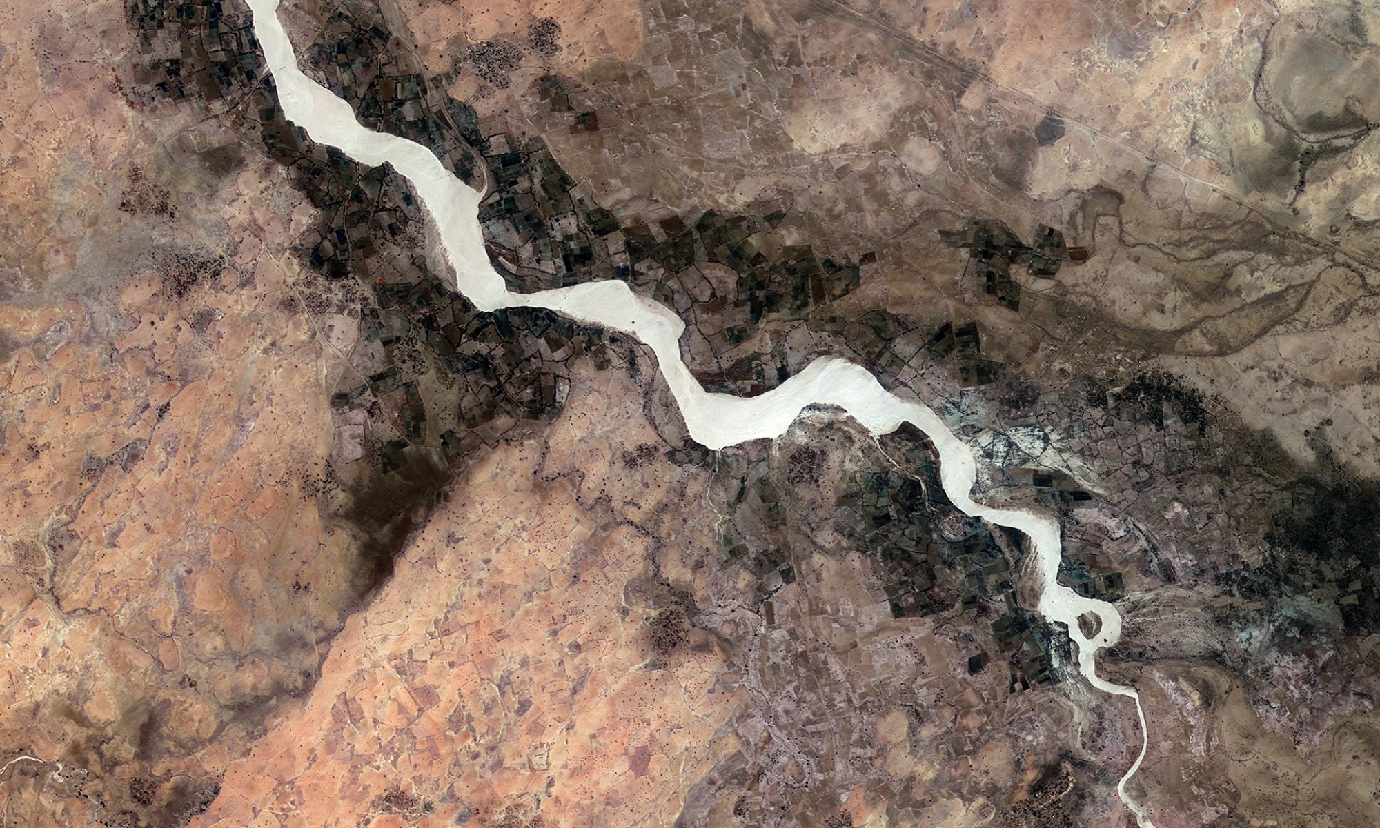

Over the last four decades, Darfur’s climate has witnessed significant changes that have both alleviated and exacerbated environmental pressures in the region. On one hand, recent data indicate an increase in annual precipitation, enhanced natural vegetation, and a noticeable decline in severe drought events. On the other, the complex legacy of prolonged conflict and environmental degradation continues to affect resource availability and socio-political stability. This report examines these multifaceted dynamics, highlighting how climatic trends intersect with issues of sustainability, conflict, and recovery.
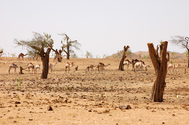
Darfur, a region at the edge of the Sahara and characterized by semi-arid to arid climatic conditions, has long been emblematic of environmental extremes. Historically burdened by persistent droughts, the area has faced severe water shortages and land degradation, which in turn have fueled competition over scarce resources. However, recent analyses indicate an evolving climatic regime—a transformation captured through remote sensing technologies and advanced climatic models. These studies not only reveal a transition in natural patterns but also offer a glimpse into how improving environmental conditions may pave the way for conflict resolution and sustainable recovery.
Climatic Trends and Data Analysis
Precipitation and Vegetation Dynamics
Recent research spanning four decades (1980–2023) has revealed a nuanced picture of Darfur’s climate. Studies employing data from the Moderate Resolution Imaging Spectroradiometer (MODIS) have tracked changes in the Enhanced Vegetation Index (EVI), showing a significant increase in vegetation cover—up nearly 33% between 2000 and 2023 in certain areas. Concurrently, analyses of the Standardized Precipitation Evapotranspiration Index (SPEI) indicate that while the region experienced prolonged drought events from the 1980s until 2012, more recent decades are marked by a reduced frequency and severity of drought. Forecasts using Autoregressive Integrated Moving Average (ARIMA) models suggest that these trends may continue, with future scenarios dependent on both natural variability and human interventions.
Beyond the Numbers: Environmental Recovery
The interplay between increased precipitation and enhanced vegetation presents an interesting counter-narrative to the historical view of Darfur as a perpetually degraded landscape. Technological tools like Google Earth Engine and ArcGIS Pro have helped policymakers and researchers alike to map these environmental shifts accurately, offering hope that positive climatic trends could serve as a foundation for environmental recovery. Such recovery is seen not just as a natural phenomenon but as a potential catalyst for reducing resource-related conflicts in the region.
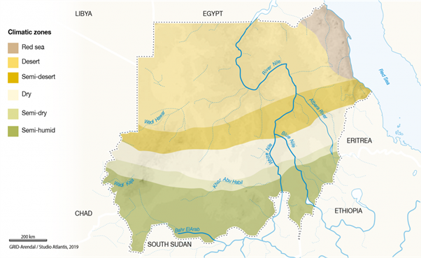
Climatic zones
The climatic zones of Darfur vary from desert to the semi-humid, as classified in Sudan National REDD+ Programme (2017). Most of Darfur’s irrigation schemes are in the dry zones, while the bulk of rain-fed agriculture lies in the semi-humid zone.
Rainfall
Darfur has no extensive bodies of water that contribute to evapotranspiration – the movement of moisture from the land to the atmosphere – and hence humidity is low in most places at most times. The effect of the Red Sea is limited and the River Nile, which traverses the Sudan from south to north, is too narrow to play much of a role.
The region draws most of its moisture from the Atlantic and Indian Oceans. It is carried north on winds that are controlled by the pressure distribution over the African continent. The winds are driven by three permanent high-pressure zones: the Azores high-pressure belt off the northwestern coast near the Tropic of Cancer, and the Saharan and Arabian high-pressure belts that lie south of the Equator in the vicinity of the Tropic of Capricorn. Another source of moisture is the permanent low-pressure belt known as the doldrums, which crosses the African continent around the Equator. This humid southerly wind system dominates the Saharan region during the summer. All Darfur’s rainfall usually falls during the summer when these southerly winds dominate the low layers of the atmosphere.
The rainy season lasts from May to October in the southern part of the region, from June to September in the northern parts. The northward movement of the rains is partly controlled by the ITCZ, which at the beginning of the rainy season is over the extreme south of the region. From May, the ITCZ moves gradually north and reaches its northernmost position in August. During this period, most parts of the region are under the influence of the southwesterly winds that carry moisture from the Atlantic Ocean and Congo basin, and the easterlies in the mid troposphere that blow from the Indian Ocean. In September, the ITCZ moves southwards rapidly, bringing the main rainy season to an end.
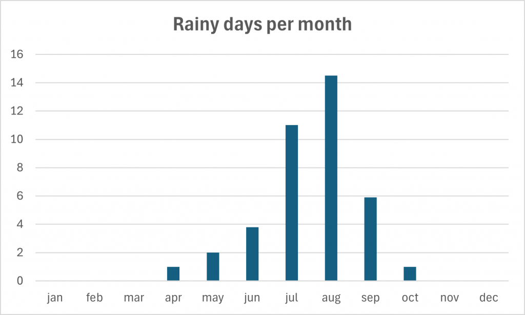
A rainy day is a day on which at least an amount of 0.1 mm precipitation (=0.1 liter) per square meter falls. This can be rain, snow, hail or even dew. So it does not have to rain the whole day. With 15 rainy days, August offers the most number of rainy days, and in December the least.
An analysis of rainfall trends from 1981 to 2016 using data from the Sudan Meteorological Authority shows that the onset of the rainy season is often delayed or the rains do not come at all in some areas, resulting in drought and sometimes famine. During the 1990s, rainfall was above average in the first part of the decade and below average during the latter years. On the coast, rainfall patterns were highly variable, though the quantity did not change significantly. Rainfall patterns in Darfur become increasingly unpredictable as one goes from south to north.
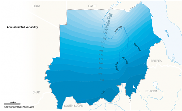
The amount of precipitation is measured in millimeters per square meter. Thus, at 2 mm/day, 2 liters of water fall on one square meter within 24 hours. With only 0 mm, the least rain falls in December. August, on the other hand, has the most rain.
Temperature
Mean annual temperatures across Sudan exhibit a range from 23 to 32°C. During the summer months, temperatures in the northern parts of Sudan, which include northern Darfur, often exceed 43°C. The climate in this region is also characterized by a significant diurnal temperature variation, frequently exceeding 15°C. The highest temperatures typically occur at the beginning and towards the end of the wet season. During these hot periods, daily temperature fluctuations can be substantial, ranging from over 20°C at night to more than 40°C during the day. In contrast, the coldest months of the year, December and January, can experience nighttime temperatures dropping below 20°C. This considerable difference between daytime and nighttime temperatures is indicative of the continental climate influence prevalent in the region and has implications for both human comfort and agricultural practices, affecting factors such as evaporation rates and the types of crops that can be cultivated.
Average monthly high and low temperatures for Darfur, based on weather reports collected between 2012 and 2021, are summarized in the following table:
| Month | Average High (°C) | Average Low (°C) | Mean Temperature (°C) |
| January | 33 | 17 | 25 |
| February | 36 | 19 | 28 |
| March | 39 | 24 | 32 |
| April | 40 | 26 | 33 |
| May | 40 | 28 | 34 |
| June | 38 | 26 | 32 |
| July | 34 | 24 | 29 |
| August | 31 | 22 | 27 |
| September | 34 | 23 | 28 |
| October | 37 | 23 | 30 |
| November | 36 | 21 | 28 |
| December | 33 | 18 | 26 |
Data from Umm Heglig in Darfur indicates a similar pattern, with daytime highs ranging from 29°C in January and December to 39°C in May, and nighttime lows from 13°C in January to 26°C in June. El Fasher in Northern Darfur experiences temperatures typically between 20°C and 31°C throughout the year, with May, June, and July being the warmest months (mean 29-31°C) and January, February, and December being the coldest (mean 20-21°C). In Garsila, Central Darfur, daily high temperatures in April often exceed 100°F. Northern Darfur generally has extremely hot summers with temperatures surpassing 40°C and mild winters with daytime temperatures between 20-30°C and nighttime temperatures around 10°C. These variations across different locations within Darfur highlight the presence of localized climate nuances within the broader regional temperature characteristics.
Sunshine hours
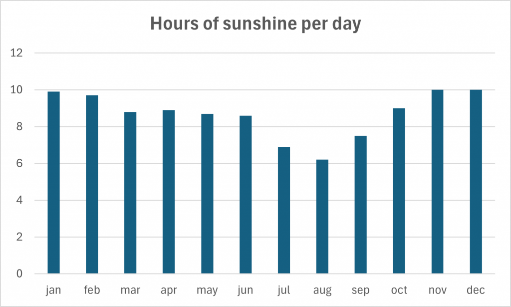
The number of hours of sunshine refers to the time when the sun is actually visible. That is, without any obstruction of visibility by clouds, fog or mountains. With 10 hours per day, November is the sunniest month in country part Western Darfur. In August the sun shines the shortest. Darfur has long hours of sunshine, which means the region has the potential to generate a significant amount of solar electricity.
Wind
Wind speeds in Darfur are sometimes so high that they cause dust and sandstorms. A violent dust storm called the haboob often occurs in central Sudan between May and July when the moist southwesterly flow arrives. The unstable air creates thunderstorms in the heat of the afternoon, and the downdraft from an approaching storm produces a yellow wall of sand and clay that can reduce visibility to zero.
The term ‘sandstorm’ is used to describe desert storms, especially in the Sahara, which in addition to fine particles that obscure visibility stir up a considerable amount of larger sand particles that travel closer to the surface. The term ‘dust storm’ tends to be used when finer particles are blown long distances, especially when the disturbance affects urban areas.
Dust storms and sandstorms are common in arid and semi-arid regions in north and west Darfur. They arise when a cold front lifts loose sand and dust particles from the dry surface of the land and carries them as a suspension. The process erodes the soil in one place and deposits it in another.
Poor farming and grazing practices can heighten the risk of dust and sandstorms by exposing the dust and sand to the wind. The storms can seriously affect transportation, telecommunications, industrial and agricultural production, and people’s lives and work. Because they remove organic matter and the nutrient- rich lightest particles, they reduce agricultural productivity, and the abrasive effect of storms damages young crop plants. Dust and sandstorms can have a critical effect on human health due to the deterioration in air quality, even causing deaths. One potential advantage of Sudan’s persistent winds is that they are strong and stable enough for the generation of wind power.
Environmental Degradation and the Conflict Nexus
Historical Degradation and Contemporary Pressures
Beyond the meteorological data, Darfur’s environmental history is deeply interwoven with its socio-political conflict. The long-standing struggle for control over diminishing resources has accelerated environmental degradation, particularly in areas where traditional patterns of land use were abruptly disrupted by conflict. Research has shown that environmental stressors like land degradation and water scarcity have intensified local conflicts, further weakening traditional environmental management practices. This degradation not only affects current subsistence livelihoods but also undermines longer-term prospects of resilience and recovery.
Climate Change as a Double-Edged Sword
The complex relationship between climate change and conflict is vividly illustrated in Darfur. On one side, the recent shifts toward increased precipitation and improved vegetation suggest that nature may be slowly healing some of its wounds, thereby reducing immediate resource pressures. On the other, these same climatic changes coexist with deep-rooted governance challenges and historical grievances. Research, such as in the study “Burning Sands, Burning Tensions: Climate Change and Conflict in Darfur,” reinforces the idea that climate change intensifies competition over resources. The increased variability in rainfall—even as overall trends point to improvement—can further destabilize vulnerable communities, fostering renewed environmental and ethnic tensions.
Socio-Environmental Impacts
Resource Scarcity and Community Resilience
For much of Darfur’s recent history, resource scarcity has been both a cause and a consequence of environmental degradation. The diminished availability of water and arable land has heightened competition between settled agriculturalists and nomadic pastoralists, thereby fueling intermittent violence. Improved climate conditions, marked by higher precipitation and vegetation recovery, are seen as providing a window for community-driven environmental recovery initiatives. Such initiatives are crucial for rebuilding traditional livelihoods and reinforcing local governance structures that can manage natural resources more equitably.
Implications for Peace and Recovery
An integrated approach to environmental management offers a pathway to mitigating conflict. By leveraging improved climatic conditions, stakeholders in Darfur can better implement sustainable resource practices and adaptive strategies to combat future climatic uncertainties. The synergy between environmental recovery and conflict resolution strategies suggests that fostering ecological resilience could be a key pillar in comprehensive peacebuilding initiatives. This requires not only technological and scientific interventions but also politically inclusive strategies that address issues of marginalization and ethnic tension.
Outlook and Recommendations
Adaptive Environmental Management
Given the dual nature of climate change in Darfur—simultaneously promising improved environmental conditions and posing challenges due to historical degradation—a nuanced, adaptive management strategy is essential. Recommendations include:
- Investing in Climate Monitoring Infrastructure: Continued investment in high-resolution remote sensing and on-ground climate monitoring will be vital for tracking changes and predicting future trends.
- Enhancing Local Governance: Strengthening community-driven environmental management can help rebuild traditional practices that foster resilience.
- Promoting Sustainable Resource Use: Implementing sustainable land, water, and resource management practices will mitigate the risk of renewed conflicts.
- Integrating Technological and Social Approaches: Combining scientific models like ARIMA forecasting with robust local initiatives will ensure that environmental improvements translate into lasting societal benefits.
Bridging Research with Policy
For policymakers, translating these climatic insights into actionable and inclusive policies is the next crucial step. Building partnerships between local governments, international agencies, and community organizations will be important for holistic environmental and peacebuilding strategies. The integration of environmental recovery with conflict resolution frameworks can serve as a robust model for other regions facing similar challenges.
Darfur’s climate, once synonymous with unyielding drought and ecological degradation, is showing signs of transformation. Enhanced precipitation and regrowing vegetation offer hope not only for ecological recovery but also for reducing resource-related conflicts that have plagued the region. Yet, the evolving climate is a double-edged sword—it brings potential benefits for environmental resilience and peacebuilding while also intensifying underlying governance and social challenges. A balanced, integrated approach that aligns climatic research with sustainable development and conflict resolution is essential for ensuring a stable and prosperous future for Darfur.